90 winemakers from the
Appellations Kamptal,
Kremstal, Traisental, Wagram,
Wien (Vienna), Carnuntum, Thermenregion and Weinviertel

ABOUT THE REGIONS
ÖTW-APPELATIONEN
Weinviertel

Weinviertel:
ÖTW.ERSTE LAGEN are to be classified
13 members

WV right OeWM WSNA noe weinviertel retz jpg
WV right OeWM WSNA noe weinviertel mannersdorf rochusberg jpg
WV right OeWM WSNA noe weinviertel retz jpg
WV right OeWM WSNA noe weinviertel mannersdorf rochusberg jpg

Weinviertel


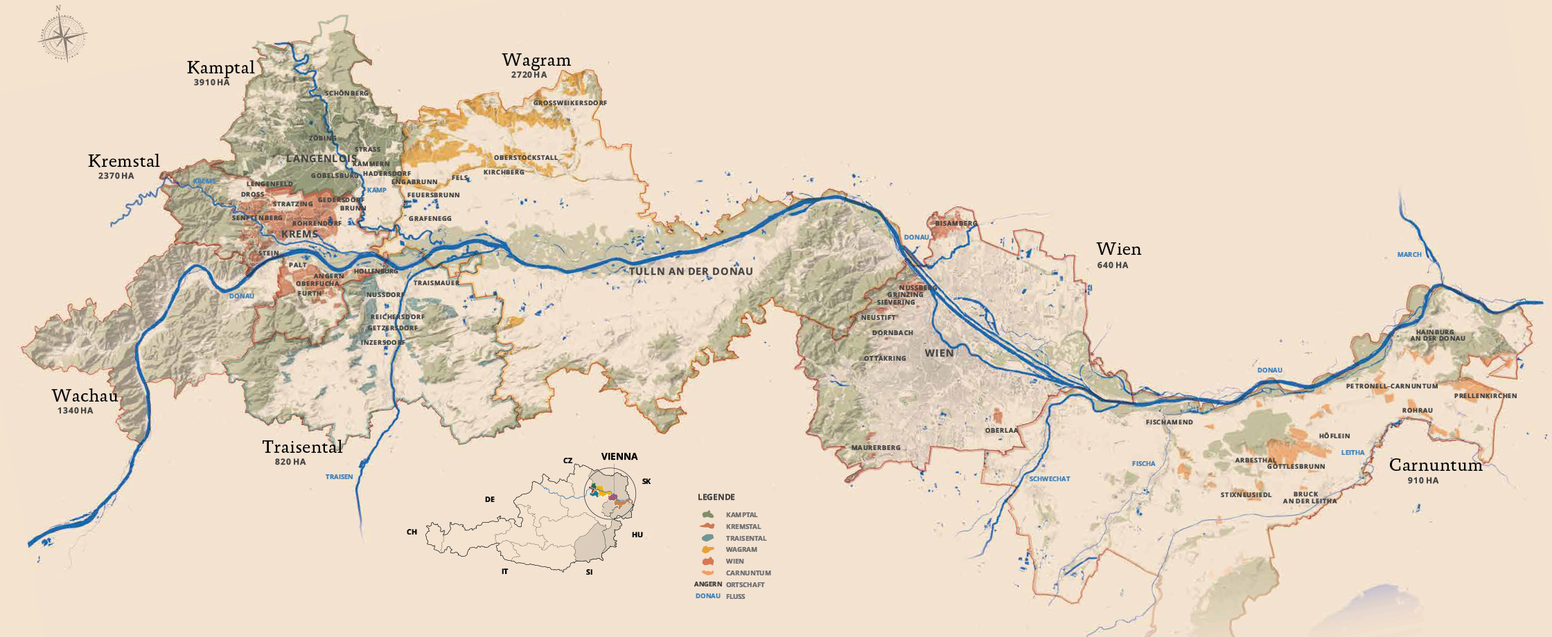
Raise the curtain on the varied natural landscape of the Weinviertel! In many places, gently undulating green vineyards, archaic-looking sunken paths and romantic cellar lanes caress the eye of the beholder. The Weinviertel is a geological link in Central Europe, as it lies at the transition between the Alps and the Carpathians. Over millions of years, a wide variety of loose rocks have been deposited here over hard rocks, forming the geological subsoil. The soil layer is formed by the weathering of this subsoil, whereby climate, water and soil organisms are also important for its composition. The Weinviertel is often referred to as "loess country", as the loess covers all older layers of rock like a soft mantle over large areas. Grüner Veltliner loves loess, which gives the wines quick accessibility, strong spiciness, lush fruit, smoothness and extract.

WV Overview OeWM WSNA noe weinviertel galgenberg Ried Galgenberg and the cellar lane in Wildendürnbach
WV outro left OeWM WSNA noe weinviertel falkenstein burgruine falkenstein ried urteln ried kirchbergen jpg The castle ruin of Falkenstein
WV outro right OeWM WSNA roeschitz weinviertel niederoesterreich Röschitz in the Weinviertel
 

Geologically, the Weinviertel can be roughly divided into two parts: Most of the western Weinviertel consists of loose sedimentary rocks such as clay, silt, sand, gravel and limestone. The oldest originate from deposits of fossil-rich sediments
of the Molasse Sea at the edge of the Bohemian Massif. Extensive cellar complexes were built in former coastal, barely consolidated sands, for example in Retz. The east of the Weinviertel is geologically assigned to the Vienna Basin, which stretches 200 km from the south of Lower Austria to the Czech Republic and Slovakia. In addition to loess, loam or limestone, gravel, sand and clay can be found here in an independent depositional area, which was created by the distortion and expansion of the subsoil at the transition from the Alps to the Carpathians.


Profile Weinviertel

  • Hectares: 13,840
  • Important places: Hohenwarth, Röschitz, Retz, Poysdorf, Falkenstein
  • Most important variety: Grüner Veltliner (50%)
  • Classified sites: from vintage 2023 onwards
  • Hours of sunshine: approx. 2,000
  • Precipitation: approx. 480 mm in the western Weinviertel, approx. 550 mm in the east
  • Average temperature: approx. 10.6°C
Location map

A complete overview of the regions and the classified vineyard sites for download as PDF.

To the top